
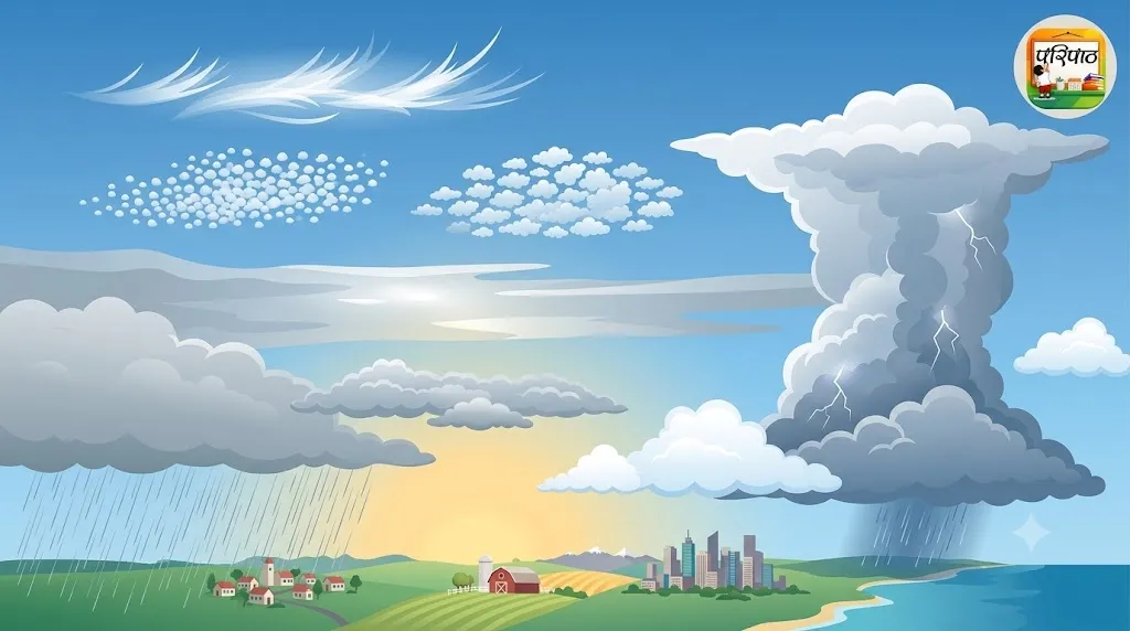
Have you ever looked up at the sky and wondered what exactly those fluffy, white, or grey masses are? Where do they come from, and why do they take on so many different shapes? Clouds are not just random patches in the sky; they are one of nature's most captivating art forms and crucial indicators of our weather. In this special feature from 'Paripath', we will dive deep into the fascinating world of clouds. We'll explore how clouds form, the different types that exist, and what they can tell us about the weather. Join us as we unravel the science behind these magnificent sky paintings!
What Are Clouds and How Do They Form?
A cloud is essentially a large collection of tiny water droplets or ice crystals suspended in the atmosphere. These droplets or crystals are so small and light that they can float in the air. Cloud formation is a natural process that plays a vital role in Earth's water cycle.
The Process of Cloud Formation:
- Evaporation: The sun's energy heats water on Earth's surface (from oceans, rivers, lakes, and plants), turning it into water vapor. This vapor, an invisible gas, rises into the atmosphere.
- Rising Warm Air: Warm, moist air is less dense than the surrounding cooler air, so it rises. As the air ascends, the atmospheric pressure decreases, causing the air to expand and cool.
- Condensation: As the air cools, the water vapor in it begins to change back into tiny liquid water droplets or ice crystals. This process is called condensation. For condensation to occur efficiently, the air needs 'condensation nuclei'.
- Condensation Nuclei: These are microscopic particles in the air, such as dust, pollen, salt crystals from the ocean, or pollution particles. Water vapor finds it easier to condense around these tiny particles to form droplets. Billions of these tiny droplets or crystals cluster together to form a visible cloud.
Amazing Fact: A single cumulus cloud can weigh more than a million pounds! Yet, because this weight is distributed among countless tiny droplets, it remains suspended in the air.
Main Types of Clouds and Their Characteristics
Clouds are classified into various types based on their altitude and appearance. Broadly, there are four main groups: high-level, mid-level, low-level, and vertically developed clouds. Let's explore each category in detail.
1. High-Level Clouds (Above 6,000 meters or 20,000 feet)
These clouds are found at high altitudes where temperatures are very low, so they are primarily composed of ice crystals. They generally appear thin and wispy.
- Cirrus:
- Description: These are thin, wispy, feather-like clouds, often appearing as delicate streaks across the sky. They are brilliant white.
- Weather Indication: Cirrus clouds usually indicate fair weather, but they can also signal a change in weather is on its way.
- Etymology: Cirrus (Latin for 'a curl of hair')
- Cirrocumulus:
- Description: Small, white, rounded cloudlets, often appearing in rows or groups. They are sometimes called 'mackerel sky' due to their resemblance to fish scales.
- Weather Indication: These clouds often suggest changing weather conditions, sometimes preceding a storm.
- Cirrostratus:
- Description: Thin, sheet-like, whitish clouds that cover the entire sky. They often produce a halo around the sun or moon due to the refraction of light by ice crystals.
- Weather Indication: Cirrostratus clouds often indicate that rain or snow will follow within 12-24 hours.
2. Mid-Level Clouds (2,000 to 6,000 meters or 6,500 to 20,000 feet)
These clouds are composed of a mixture of water droplets and ice crystals.
- Altocumulus:
- Description: Medium-sized, white or grey, puffy clouds that appear in patches or parallel bands. They often resemble 'sheep in a flock'.
- Weather Indication: Altocumulus clouds generally signify fair weather, but if they thicken, they can sometimes precede thunderstorms.
- Altostratus:
- Description: Grey or bluish-grey cloud sheets that cover the entire sky. They partially obscure the sun or moon, making it appear as a dimly lit disk.
- Weather Indication: Altostratus clouds often indicate widespread rain or snow is approaching.
3. Low-Level Clouds (Below 2,000 meters or 6,500 feet)
These clouds are close to the Earth's surface and are primarily composed of water droplets.
- Stratus:
- Description: Grey, featureless cloud sheets that cover the entire sky, giving the atmosphere a dull, overcast appearance. Fog is essentially a stratus cloud that forms very close to the ground.
- Weather Indication: Stratus clouds usually bring light drizzle or mist and generally indicate stable, often gloomy weather.
- Etymology: Stratus (Latin for 'layer' or 'sheet')
- Stratocumulus:
- Description: Large, rounded, grey or whitish clouds that occur in patches or rolls. They often have clear skies visible between them.
- Weather Indication: Stratocumulus clouds usually indicate fair weather, but they can sometimes produce light rain or snow.
- Nimbostratus:
- Description: Dark grey, thick, and widespread cloud sheets that obscure the sun and moon. They are associated with continuous rain or snow.
- Weather Indication: Nimbostratus clouds are clear indicators of prolonged, moderate to heavy precipitation (rain or snow).
4. Vertically Developed Clouds (Extending from low to high altitudes)
These clouds start close to the ground and extend upwards through significant portions of the atmosphere. They are composed of both water droplets and ice crystals.
- Cumulus:
- Description: White, puffy, cotton-like clouds with flat bases and rounded tops, resembling cauliflower. They are often seen on sunny days.
- Weather Indication: Small cumulus clouds are known as 'fair-weather clouds' and indicate stable, clear conditions. However, if they grow larger and taller, they can develop into cumulonimbus clouds.
- Etymology: Cumulus (Latin for 'heap' or 'pile')
- Cumulonimbus:
- Description: These are the largest and most powerful clouds, towering from near the ground to very high altitudes. They appear massive and dark, often with an 'anvil' shaped top.
- Weather Indication: Cumulonimbus clouds are clear indicators of thunderstorms, lightning, heavy rain, hail, and sometimes even tornadoes. They are the most dangerous weather-producing clouds.
Clouds as Weather Predictors
Understanding cloud types allows us to predict weather patterns, a practice humans have engaged in since ancient times. Each cloud type carries its own unique characteristics and a specific weather message.
- Fair Weather Clouds: Thin cirrus and small, scattered cumulus clouds generally indicate clear and stable weather.
- Rain Clouds: Nimbostratus clouds signify prolonged rain, while cumulonimbus clouds are harbingers of thunderstorms and heavy downpours. Altostratus clouds also suggest the possibility of rain.
- Changing Weather Clouds: Cirrostratus and altocumulus clouds often indicate a change in weather is approaching. The halo around the sun or moon caused by cirrostratus is often considered a sign of rain within 12-24 hours.
- Fog and Drizzle: Stratus clouds, when close to the ground, form fog and can cause light drizzle.
Cloud observation remains a crucial tool for meteorologists. Before the advent of satellite and radar technology, studying clouds was the primary method for forecasting weather. Even today, local cloud observations are incredibly useful for short-term weather predictions.
The Wonderful World of Clouds and Scientific Curiosity
The world of clouds is not just about weather; it's filled with scientific wonder and aesthetic beauty. Every cloud is a unique masterpiece, a symbol of nature's constantly changing canvas. By observing clouds, you're not just predicting weather; you're engaging in the study of complex atmospheric processes. Rainbows within clouds, the shifting colors of clouds at sunset, and the dramatic formations before a storm are all parts of nature's incredible show.
It's important for students to observe clouds, try to identify their types, and understand their relationship with the weather. This will enhance your observation skills and foster greater environmental awareness. Who knows, maybe you'll be a successful meteorologist one day!
Did You Know?
- Cloud Weight: A typical cumulus cloud can weigh approximately 550,000 kilograms (which is about the weight of 100 elephants)!
- Cloud Naming: The Latin names given to clouds (e.g., Cumulus, Stratus, Cirrus, Nimbus) were introduced by British meteorologist Luke Howard in 1803.
- Highest Clouds: Cumulonimbus clouds can extend from near the Earth's surface up to 18 kilometers (about 59,000 feet) into the atmosphere.
- Night-Shining Clouds: Noctilucent clouds are the rarest and highest cloud type, appearing in the mesosphere, about 75-85 kilometers (47-53 miles) above the Earth's surface.
- Cloud Colors: The color of clouds depends on their thickness and how much sunlight they absorb. Thin clouds appear white because they scatter all colors of light equally, while thicker clouds appear darker or grey because they absorb more sunlight.
Conclusion
In this article, we've explored the fascinating world of clouds. We've learned how clouds form, their various types (Cirrus, Cumulus, Stratus, Nimbus, and their sub-types), and what they tell us about the weather. Clouds are not just beautiful sights in the sky; they are an integral part of our planet's water cycle and weather system. By observing clouds, we can gain valuable insights into our surrounding environment and appreciate this amazing art form of nature. The next time you look up at the sky, try to understand the science and story behind each cloud. It will give you a new perspective and strengthen your connection with nature.